Reading the St Anton piste map for a refined ski holiday
The St Anton piste map is the essential starting point for planning a refined ski holiday in the Arlberg. When you study the map before booking, you immediately see how the ski area connects St. Anton am Arlberg with Lech, Zürs, and Warth Schröcken. This overview helps luxury travelers match their preferred ski routes, snow conditions, and hotel locations with precision.
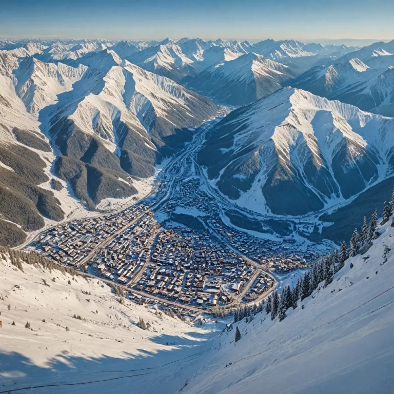
St. Anton am Arlberg is a flagship ski resort in Tyrol, renowned for challenging pistes and a lively après ski scene. The official piste map shows more than 300 km of groomed pistes and 85 lifts, which is crucial information when comparing ski resorts for longer ski trips. By combining the piste map with a live snow report and weather snow forecast, you can align your ski day with the most suitable slopes and minimize time spent in queues.
For advanced skiers, the St Anton piste map highlights steep pistes above the Galzig and Valluga lifts, while intermediates can focus on the wide ski area around Gampen and Kapall. Beginners benefit from clearly marked blue pistes near the village and gentle ski routes that link to quieter parts of the resort. Luxury hotels near the main lifts allow you to step from breakfast directly onto the piste, turning the map into a daily guide rather than a simple trail map.
Using the piste map to choose the right luxury hotel location
For premium hotel booking in Austria, the St Anton piste map is as important as any photo gallery. Guests who value ski in ski out convenience should look at hotels close to the Galzigbahn and Rendlbahn lifts on the map. This central area offers quick access to the wider ski area and short walks back from après ski venues at the end of the day.
Travelers who prefer quieter evenings may select resorts or chalets slightly away from the main après strip, yet still within a few minutes of key lifts and pistes. By cross checking the piste map with an interactive map of the village, you can see how far each property sits from ski routes, ski bus stops, and late night noise. This approach mirrors how discerning guests compare superior rooms and suites in other destinations, such as those highlighted in this guide to Mallorca hotels with superior rooms, comfort, and style.
Many five star properties in the resort offer private shuttles to the lifts, which changes how you read distance on the St Anton piste map. A two minute drive can feel easier than a five hundred metre walk in heavy snow with ski equipment. When you combine hotel services, the piste map, and live weather snow updates, you can design a stay that balances comfort, access, and atmosphere.
Connecting St Anton with Lech, Zürs, and Warth Schröcken on one map
The full ski Arlberg piste map shows how St. Anton links with Lech, Zürs, and Warth Schröcken to form one of Europe’s largest connected ski areas. Luxury travelers often underestimate how much time it takes to cross from one ski resort to another, so studying the piste map in advance is essential. Long ski routes, multiple lifts, and changing weather snow conditions can all affect how many valleys you comfortably cover in a single day.
On the map, you will see that the main ski area above St. Anton connects via St. Christoph and Stuben towards the Flexenbahn, which leads to Lech Zürs. This connection allows you to plan elegant ski safaris, starting from your hotel in St. Anton and finishing the day with lunch or après in another resort. When you book premium accommodation, it is worth checking whether your property offers flexible breakfast times and late spa access to support these longer ski trips.
For guests comparing price guarantee offers across ski resorts, the scale of ski Arlberg can justify higher nightly rates. A single ski pass unlocks a vast network of pistes, lifts, and off piste options, all clearly marked on the piste map and the resort interactive tools online. For deeper planning, many travelers use a digital interactive map alongside a traditional ski map, ensuring they understand every piste, ski route, and return option before committing to a full circuit.
Leveraging live reports, weather, and snow data for safe luxury skiing
Modern luxury ski travelers expect more than a static trail map when they arrive in St. Anton am Arlberg. The resort operator provides an interactive map with live lift status, piste openings, and a detailed snow report, which is invaluable for planning each ski day. “Check the interactive piste map for real-time lift and piste status.”
By combining the St Anton piste map with a daily report ski update, you can adapt your plans to changing weather snow conditions. On days with fresh snow and lower visibility, you might stay in tree lined areas of the ski area, while clear days invite high alpine pistes above 2 800 m. Luxury hotels with attentive concierges often brief guests each morning, using the latest snow report and piste map details to suggest the best routes.
Safety is a key concern, especially for advanced skiers exploring challenging pistes or sidecountry ski routes. The ski resort invests heavily in grooming, avalanche control, and lift maintenance, which supports both comfort and security for guests. When you book through a specialist platform with a strong price guarantee and curated premium properties, you also gain access to expert advice similar to that shared in this overview of premium hotel booking in Austria with luxury and elegance.
Matching piste difficulty and après ski with hotel style
The St Anton piste map clearly grades pistes by difficulty, which helps align your skiing with the style of hotel you prefer. Families and cautious intermediates may focus on gentle pistes and ski routes near Nasserein, then choose quieter resorts or chalets in that area. Advanced skiers who enjoy steep terrain and vibrant nightlife often stay closer to the main après ski hubs in the village centre.
Apres ski in St. Anton is famous, with venues near the bottom of key pistes drawing crowds every afternoon. When you read the piste map, note which runs lead directly to these bars and terraces, then consider how far your hotel lies from the noise. Some luxury properties offer soundproofed rooms and private lounges, allowing guests to enjoy the atmosphere of the ski resort without sacrificing rest.
For multi day ski trips, it is wise to alternate intense days on advanced pistes with easier days exploring the wider ski area. The map helps you design circuits that include scenic ski routes to Lech Zürs or Warth Schröcken, followed by relaxed lunches in mountain restaurants. By pairing this thoughtful planning with a strong price guarantee on your accommodation, you can enjoy both value and indulgence across several ski resorts in the Arlberg.
Digital tools, interactive maps, and practical booking tips for St Anton
Digital tools have transformed how guests use the St Anton piste map when booking luxury stays. Many travelers now consult a resort interactive platform that combines the ski map, live weather snow data, and hotel locations in one interface. This allows you to filter ski resorts by altitude, piste length, and proximity to lifts before confirming any reservation.
When evaluating options in the ski Arlberg region, compare how each ski resort presents its piste map, snow report, and price guarantee policies. Transparent details about lifts, pistes, and ski routes indicate a well managed ski area that values guest experience. St. Anton am Arlberg stands out for its extensive network of 300 km of pistes and 85 lifts, which supports both short breaks and longer ski trips.
For the most seamless experience, save a digital copy of the piste map, the interactive map, and your hotel confirmation on your phone. This ensures you always have access to key details about the ski area, resort transfers, and daily report ski updates. By combining these tools with the expertise of the St. Anton am Arlberg Ski Resort team at [email protected], you can craft a stay where every piste, lift, and evening in the village aligns with your expectations for refined alpine travel.
Key statistics for the St Anton piste map and ski Arlberg
- Total groomed pistes in the St. Anton am Arlberg ski area : 300 km.
- Number of ski lifts, including cable cars, chairlifts, and surface lifts : 85.
- Resort base altitude in St. Anton am Arlberg : approximately 1 304 m.
- Highest lift accessible point in the ski area : approximately 2 811 m.
Essential questions about the St Anton piste map and luxury stays
What is the best time to visit St. Anton for skiing ?
The ski season in St. Anton am Arlberg typically runs from early December to mid April, with the most reliable snow conditions often found in mid winter. When you study the St Anton piste map alongside a current snow report, you can identify which pistes and ski routes are likely to be open during your preferred travel window. Luxury travelers often target periods with good weather snow balance, combining deep snow cover with enough sunshine for long days across the wider ski area.
Are there ski schools available for beginners ?
St. Anton am Arlberg offers several ski schools that cater to all skill levels, including complete beginners and children. When you look at the piste map, you will see dedicated beginner areas and gentle blue pistes near the village, which are ideal for lessons. Many premium hotels work closely with these schools, arranging private instructors, ski passes, and convenient meeting points close to key lifts and pistes.
How can I access the interactive piste map ?
The interactive piste map for St. Anton am Arlberg is available on the official resort website and through the ski Arlberg app. This digital tool provides real time information on lift openings, piste status, and weather snow updates across the entire ski area. By combining the interactive map with your hotel’s concierge advice, you can plan each ski day with confidence, from first lift to the final run back to your chosen resort.